Interactive GTA 6 map on Rockstar's official Leonida map: 2,600+ places, shops, stunt jumps, races, safes and collectibles, with filters and search.
FAQ
Is there an official GTA 6 interactive map?
Does the GTA 6 map show collectibles?
Why are some places hidden?
How accurate are the markers?
How to use the map
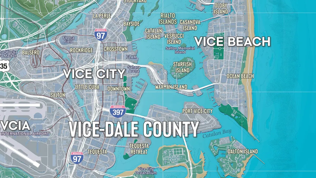
The map at the top of this page is Rockstar’s official map of Leonida with every confirmed place marked on it.
- Choose what to show. Tick or untick categories in the left panel. Places and collectibles each have their own group, and the number beside each category is how many points it has. Bus stops, ATMs, food stops and other crowded categories appear once you zoom in.
- Select a marker to see its name, where it is and what is there. Collectibles, stunts, races, safes and other one-off finds have a Found box; ticked ones fade on the map and count toward the totals in the left panel. Progress is saved in this browser only.
- Search by name or place, then pick a result to go straight to it.
- Jump to an area with the menu at the bottom of the left panel.
On a phone, the Filters button above the map opens the panel.
Everything on the map
Open a category to read every entry in it. Selecting a name shows that marker on the map.
| On the map | Group | Points |
|---|---|---|
| Districts | Places | 31 |
| Landmarks | Places | 24 |
| Story & safehouses | Places | 4 |
| Stations, ports and airports | Places | 25 |
| Contacts | Robberies & crime | 10 |
| Illegal operations | Robberies & crime | 40 |
| Safes | Robberies & crime | 40 |
| Towable ATMs | Robberies & crime | 99 |
| Gun shops | Shops and services | 24 |
| Clothing and shoes | Shops and services | 84 |
| Hair and beauty | Shops and services | 18 |
| Tattoo parlors | Shops and services | 11 |
| Banks and loans | Shops and services | 25 |
| Jewelry stores | Shops and services | 16 |
| Pawn shops | Shops and services | 13 |
| Electronics | Shops and services | 15 |
| ATMs | Shops and services | 193 |
| Other shops | Shops and services | 3 |
| Convenience stores | Food & drink | 72 |
| Fast food | Food & drink | 21 |
| Cafes & takeout | Food & drink | 89 |
| Bars | Food & drink | 117 |
| Liquor stores | Food & drink | 14 |
| Street food | Food & drink | 95 |
| Mod shops | Vehicles | 14 |
| Pay ’N’ Spray | Vehicles | 19 |
| Garages | Vehicles | 12 |
| Standout vehicles | Vehicles | 85 |
| Vehicle requests | Vehicles | 16 |
| Vehicle rentals | Vehicles | 2 |
| Gas stations | Vehicles | 57 |
| Car washes | Vehicles | 6 |
| EV chargers | Vehicles | 89 |
| Bus stops | Vehicles | 276 |
| Other activities | Activities | 9 |
| Races & trials | Activities | 53 |
| Drone races | Activities | 42 |
| Gyms | Activities | 9 |
| Nightclubs | Activities | 5 |
| Shooting ranges | Activities | 15 |
| Fishing hotspots | Activities | 35 |
| Pool tables | Activities | 17 |
| Arcade machines | Activities | 31 |
| Basketball hoops | Activities | 100 |
| Stunt jumps | Stunts | 130 |
| BASE jumps | Stunts | 25 |
| Knife flights | Stunts | 40 |
| Under the bridge | Stunts | 202 |
| WAiNK landmarks | Collectibles | 31 |
| WAiNK curiosities | Collectibles | 35 |
| WAiNK sculptures | Collectibles | 23 |
| PeeWee billboards | Collectibles | 0 |
| Meditation spots | Collectibles | 7 |
| Collectible cards | Collectibles | 90 |
| Magazines | Collectibles | 29 |
| Book swaps | Collectibles | 7 |
| Unique playlists | Collectibles | 7 |
| 1010 murals | Collectibles | 5 |
Districts (31)
- Abismo Key :Key next to Key Lento, linked by a bridge with a stunt jump.
- Balsero :West-side neighbourhood with Randy’s garage and the Griffin Shooting Range.
- Bayside Awaiting confirmation :Reported Vice City district with a Lombank branch.
- Belpoint :Island settlement west of Capri.
- Belville :Leonard County town with a biker hideout and a college campus.
- Capri :Upscale town of luxury shops and big homes, with a train station and a muscle-car dealer.
- Corsair Key :Key with a dolphin sculpture in the water near the road west.
- Crosstown :Vice City neighbourhood with its own train station; Rideout Customs is here.
- Downtown :The high-rise core of Vice City around Catalan Blvd.
- Draper Island :Island off the Kelly County coast with a restricted warehouse area and a train station.
- Emerald Springs :Rural area along the Emerald River east of Port Gellhorn, with farms, a cafe and a diving spot.
- Gloriana Key :Built-up key with an abandoned stadium at its southern end; it hosts Hit ’N Run races.
- Goose Key :Island at the far south-west corner of the map.
- Grayson :Small town on SR-45 with a church, a train station and a motorcycle workshop.
- Hamlet :Town south of Vice City with a prison, a speedway and a salon.
- Key Lento :Island town south of Vice City where Jason’s part of the story begins.
- La Perle :Neighbourhood where the fence Tyrone lives; it also hosts Hit ’N Run street races.
- Little Cuba :Neighbourhood Rockstar introduces through its bakeries; the fence Yasmani works here.
- Manifest Canyon :Canyon north of Rodgers Ranch with an apple orchard and a large monument.
- Maroon Key Awaiting confirmation :Reported key south of Key Lento with a radar station.
- Moreau :Area on the west side of Kalaga with a gas station, an old gold mine and paper mill ruins.
- Ocean Beach :Beach district of white sand and pastel Art Deco hotels, part of Vice Beach.
- Peacock Bay Awaiting confirmation :Reported waterfront area of Vice City with bank branches.
- Permit Keys :Island group with a derelict spy ship and a beach party spot.
- Riquezas Keys :Outer island group with a large radar dome you can scan.
- Rockridge Awaiting confirmation :Reported neighbourhood with a bank and a payday loan store.
- Salton Awaiting confirmation :Reported area that hosts Hit ’N Run street races.
- Shoeless Keys :Keys area with a cafe and a Grassrivers visitor-centre statue.
- Southside :Southside Vice City, turf of the PTT Youngin$ gang.
- Starfish Island :Island of large mansions in the bay.
- Stockyard :Streetwear and tattoo neighbourhood, home of Stock 305 and Electric Fang.
- Tequesta Awaiting confirmation :Reported neighbourhood with a train station, a bank vault and a gun shop.
- Vice Beach :The long beachfront east of downtown that takes in Ocean Beach, Washington Beach and Leaf Links.
- Waning Sands :Leonard County town with a train station and two golf courses.
- Washington Beach :Beach neighbourhood with a canal dock, where the Ultimate Edition Shitzu Squalo boat waits.
- Watson Bay :Mariana County area with Paradise Garage, a safehouse, a bank and a drone course.
- Wild Hog Point :Headland in the Port Gellhorn area.
Landmarks (24)
- Allied Crystal sugar refinery :The sugar refinery that provides most of Ambrosia’s jobs.
- Belpoint Lighthouse :Lighthouse at the southern tip of Belpoint; a landmark scan.
- Dock Ring :Giant Ferris wheel off Catalan Blvd in Downtown; one of the landmarks you can scan.
- Downtown Periscope :Landmark scan reported close to Catalan Blvd in Downtown.
- Farmer Scrumpy’s Apple Orchard :Orchard in Manifest Canyon; scan the main building.
- Gambit Bay :Fishing waters Rockstar names in the Shitzu Squalo boat description.
- Gellhorn Fun Fair :Old funfair with a big Ferris wheel on Shore Dr; a landmark scan.
- Grayson Assembly :Church on SR-45 in Grayson; a landmark scan.
- Hoffman Observatory :Hilltop observatory looking out over Vice City; a landmark scan.
- Howe Dairy Farm :Reported cow-painted silo in Emerald Springs that you can scan.
- Imperial Spanish Ruins :Ruins on the south-west peak of the national park; a curiosity scan.
- Kalaga Lookout :Lookout on a peak with an astronaut mural; a landmark scan.
- Kalaga Reservoir :Reservoir in the Kalaga backcountry.
- Lake Leonida :The largest inland lake, right beside Ambrosia.
- Lawton Co. Paper Mill :Ruined paper mill beside Adler Creek, just north of the Moreau gas station; a landmark scan.
- MacAlister Gold Mine :Old gold mine in Moreau.
- Mile Zero Air Station :Military base on Goose Key with jets, tanks and helicopters. Trespassing brings a high wanted level.
- Ocean View Hotel :Classic Ocean Beach hotel on Shore Drive; the Vintage Vice City Pack’s ’55 Vapid Stanier is collected outside.
- Pegassi Residences :Residential tower with an underground garage; the Ultimate Edition ’95 Grotti Cheetah is picked up here later in the story.
- Richard Barebone State Park :State park crossed by a freeway, with a stunt jump.
- Sky Ride :Old sky-ride attraction east of the Emerald River; a landmark scan.
- Tortoise Lake :Lake inside Capri; a scannable “Halloween House” is in the streets to its south.
- Tucker’s Citrus Farms :Reported water tower in Emerald Springs that you can scan.
- Y Hotel :Washington Beach hotel right beside the canal dock.
Story & safehouses (4)
- Hamlet Correctional :The prison where Lucia starts the game.
- Jason’s House :Jason’s first safehouse, a stilt house by the marina. Sleep here to change the time of day.
- Paradise Garage :Ultimate Edition garage in Watson Bay for the ’67 Vapid Dominator Buggy, with a weapon locker and a stolen-goods drop.
- Shore Court Garage :Vintage Vice City Pack garage near Ocean Beach, with a weapon locker and a drop-off for stolen goods.
Stations, ports and airports (25)
- Courthouse :Train station in the Downtown area.
- Crosstown :Train station in the Crosstown area.
- Dalton Island :Ferry terminal in the Dalton Island area.
- Downtown :Train station in the Downtown area.
- Downtown North :Train station in the Downtown area.
- Draper Island :Train station in the Draper Island area.
- Manatees Stadium :Train station in the Rockridge area.
- Millport :Train station in the Millport area.
- Peacock Bay :Train station in the Tequesta® area.
- Port Gellhorn :Train station in the Gellhorn area.
- Port Vice City :Vice City’s cruise port, labelled Port Vice City on the official map; Rockstar calls it the cruise-ship capital of the world.
- Shoreline Park :Train station in the Downtown area.
- SND Data Center :Train station in the Grassrivers area.
- Southpoint Airfield Awaiting confirmation :Reported airfield used for delivery side jobs.
- Tequesta :Train station in the Tequesta area.
- Tequesta North :Train station in the Tequesta area.
- Vice City Airport Central :Train station in the Salton area.
- Vice City Airport Central :Train station in the Salton area.
- Vice City Airport Terminal :Train station in the VCIA area.
- Vice City Airport Village :Train station in the Salton area.
- Vice City Arts Center :Train station in the Crosstown area.
- Vice City Central :Train station in the Salton area.
- Vice City International Airport (VCIA) :The main airport, with two long runways on the south-west side of the city. Jets can be stolen, but the area is guarded.
- Vice Civic Center :Train station in the Downtown area.
- Vice Civic Center :Train station in the Downtown area.
- Waxman Island :Ferry terminal in the Waxman Island area.
Contacts (10)
- Brian’s Lockup
- Donnie’s Trailer
- Dunk’s Trailer
- Kenton’s shop :Reported shop of Kenton, who runs treasure diving.
- Killtelligence Provisions
- Moses :Vehicle fence that buys stolen cars without trackers. Opens in Chapter 2.
- Pete
- Randy’s Garage :Vehicle fence in Balsero that buys certain high-end cars, including ones with advanced trackers. Opens in Chapter 3.
- Tyrone :Fence in La Perle who pays best for narcotics. Opens in Chapter 3.
- Yasmani’s Shop :Fence in Little Cuba who pays well for jewellery and marked bills. Opens in Chapter 3.
Illegal operations (40)
- Backroom Weed Front
- Biker Hideout (Final Chapter)
- Brooks Boatworks :Gang operation in the north-east of the area; the codes for the three Port Gellhorn safes are found here.
- Carter Mining Boathouse
- Casa Guardia (The Guardia Brothers)
- Chatfield Storage & Logistics
- Cigar Import Front
- Exotic Animals Front :Robbable operation behind Three Sheets Liquor, with a safe that opens without a code.
- Fam Fix Meth Lab (Final Chapter)
- Fishing Shacks :Robbable gang operation in the swamps north-west of Key Lento, open from Chapter 1.
- Gas Station Meth Front
- Hog Stars Garage (Final Chapter)
- Illegal Goods Store (PTT Youngin$)
- Illegal Sneaker Trade (San4San)
- Industrial Weed Grow
- Irons Building Supply (Final Chapter)
- Janjak’s Garage (San4San)
- June Warehouse (Kolt & Associates)
- Kamar Devon Community Center (PTT Youngin$)
- Kingpin Bowling :Bowling alley run as a gang operation that you can rob.
- La Cascara Motel :Motel used as a gang operation; one of the better early robberies for money.
- La Perle Trap House (San4San)
- Leonida Carrier Warehouse
- Manatee Motel :Reported robbable operation in the swamps north-west of Key Lento.
- Mill Station Radar Base
- Nova Auto Junkyard (M7)
- Ocean Beach Lab
- Palmer Fishing Warehouse (La Polilla Negra)
- Parlor Apartments (San4San)
- Saber Shipping Facility (The Guardia Brothers)
- Saber Shipping Yard (The Guardia Brothers)
- Slator Towing Inc
- Sound4Sound Studio (San4San)
- Southside Trap House (PTT Youngin$)
- Stash House (Kolt & Associates)
- Sunrise RV Park (Kingfishers)
- Vespucci Mansion
- Walker Farm
- Watson Bay Safehouse (La Polilla Negra)
- Weed Grow (M7)
Safes (40)
- Backroom Weed Front (Locked Safe)
- Biker Hideout (Safe)
- Brooks Boatworks (Office Safe)
- Brooks Boatworks (Warehouse Safe)
- Carter Mining Boathouse (Locked Safe)
- Casa Guardia (Safe)
- Chatfield Storage & Logistics (Office Safe)
- Cigar Import Front (Safe)
- Exotic Animal Front (Safe)
- Farm Fix Meth Lab (Safe)
- Hog Stars Garage (Office Safe)
- Illegal Goods Store (Safe)
- Illegal Sneaker Trade (Safe)
- Industrial Weed Grow (Safe)
- Irons Building Supply (Safe)
- Janjak’s Garage (Safe)
- June Warehouse (Safe)
- Kingpin Bowling (Office Safe)
- La Cascara Motel (Lieutenant Room Safe)
- Leonida Carrier Warehouse (Safe)
- Manatee Motel (Safe)
- Mill Station Radar Base (Locked Safe)
- Nova Auto Junkyard (Garage Safe)
- Ocean Beach Lab (Safe)
- Palmer Fishing Warehouse (Safe)
- Parlor Apartments (Safe)
- Saber Shipping Facility (Office Safe)
- Saber Shipping Facility (Safe)
- Safe
- Slator Towing Inc (Safe)
- Sound4Sound Studio (Safe)
- Stash House (Safe)
- Sunrise RV Park (Office Safe)
- Sunset RV Park (Dock Warehouse Safe)
- Vespucci Mansion (Armory Safe 2)
- Vespucci Mansion (Armory Safe)
- Walker Farm (Locked Safe)
- Watson Bay Safe House (Safe)
- Weed Grow (RV Safe)
- Weed Grow (Safe)
Gun shops (24)
- Barrage Gun Supply :Gun shop in the Southwind area.
- Biff’s Gun Supply :Gun shop in the Ambrosia area.
- Big Shots :Gun shop in the Hamlet area.
- Black Eagle :Gun shop in the Balsero area.
- Chuck’s Tackle & Shot :Gun shop in the Key Lento area.
- Gellhorn Outfitters :Gun shop in the Gellhorn area.
- Guns Aplenty! :Gun shop in the Grassrivers area.
- Hamlet Traders :Gun shop in the Hamlet area.
- Iron & Oak :Gun shop in the Stockyard area.
- Jackson Firearms :Gun shop in the Salton area.
- Martez Empeños :Gun shop in the Little Cuba area.
- Pawn & Gun (Crosstown) :Gun shop in the Crosstown area.
- Pawn & Gun (Port Gellhorn) :Gun shop in the Gellhorn area.
- Phil’s Ammu-Nation :Gun shop in the Southside area.
- Prestige Firearms :Gun shop in the Vice Beach area.
- Quickscope :Gun shop in the Downtown area.
- Richardson Hunting Supplies :Gun shop in the Big Pine area.
- Rusty Willis Jr. Hunting Supplies :Gun shop in the Lummox County area.
- Tactical Outlet Guns :Gun shop in the Leonard County area.
- Tequesta Guns & Ammo :Gun shop in the Tequesta® area.
- Vice City Firearms :Gun shop in the Tequesta® area.
- Vice City Gun & Pawn :Gun shop in the Rockridge area.
- Woodhatch :Gun shop in the Capri area.
- Zenon’s Pawn Shop :Gun shop in the La Perle area.
Clothing and shoes (84)
- Aline’s Thrift Store :Clothing store in the La Perle area.
- Alpha Sports (Downtown) :Clothing store in the Downtown area.
- Alpha Sports (Ocean Beach) :Clothing store in the Vice Beach area.
- Alpha Sports (Ocean Beach) :Clothing store in the Ocean Beach area.
- Alpha Sports (Ocean Beach) :Clothing store in the Vice Beach area.
- Alpha Sports (Ocean Beach) :Clothing store in the Ocean Beach area.
- Alpha Sports (Waning Sands) :Clothing store in the Leonard County area.
- Bargain World :Clothing store in the Gellhorn area.
- Beach Please :Clothing store in the Vice Beach area.
- Billie’s Key Lento Gift Shop :Clothing store in the Key Lento area.
- Callus (Capri) :Shoe store in the Capri area.
- Callus (Decor District) :Shoe store in the Stockyard area.
- Callus (Ocean Beach) :Shoe store in the Vice Beach area.
- Callus (Ocean Beach) :Shoe store in the Ocean Beach area.
- Callus (Waning Sands) :Shoe store in the Leonard County area.
- Coastal Souvenirs :Clothing store in the Ocean Beach area.
- Coquina Box :Clothing store in the Downtown area.
- De’Luge Swimwear :Clothing store in the Vice Beach area.
- Dock Ring Souvenirs :Clothing store in the Downtown area.
- Dollar Domain :Clothing store in the Balsero area.
- Dr Froogal :Clothing store in the Stockyard area.
- Drip Drops :Clothing store in the La Perle area.
- Endzone (Downtown) :Clothing store in the Downtown area.
- Endzone (Ocean Beach) :Clothing store in the Ocean Beach area.
- Endzone (Ocean Beach) :Clothing store in the Ocean Beach area.
- Endzone (Washington Beach) :Clothing store in the Vice Beach area.
- Eris :Clothing store in the Downtown area.
- Ferruccio Tucci (Capri) :Clothing store in the Capri area.
- Ferruccio Tucci (Decor District) :Clothing store in the Stockyard area.
- Ferruccio Tucci (Ocean Beach) :Clothing store in the Vice Beach area.
- Ferruccio Tucci (Ocean Beach) :Clothing store in the Vice Beach area.
- Ferruccio Tucci (Waning Sands) :Clothing store in the Leonard County area.
- Flip Flop House :Shoe store in the Key Lento area.
- Gifts A GoGo :Clothing store in the Vice Beach area.
- Hamlet Thrift :Clothing store in the Hamlet area.
- Island Gifts :Clothing store in the Downtown area.
- Key Lento Kahuna :Clothing store in the Key Lento area.
- Knick Knack Paddle Shack :Clothing store in the Downtown area.
- Larry’s Lagoon :Clothing store in the Vice Beach area.
- Leroy’s :Clothing store in the Key Lento area.
- Little Cuba Souvenir Store :Clothing store in the Little Cuba area.
- Lost Mines Souvenirs :Clothing store in Capri and Watson Bay.
- MID (Ocean Beach) :Clothing store in the Vice Beach area.
- MID (Ocean Beach) :Clothing store in the Ocean Beach area.
- MID (Waning Sands) :Clothing store in the Leonard County area.
- Nifty Threads Island Wear :Clothing store in the Key Lento area.
- Nola (Capri) :Clothing store in the Capri area.
- Nola (Decor District) :Clothing store in the Stockyard area.
- Nola (Ocean Beach) :Clothing store in the Vice Beach area.
- Nola (Ocean Beach) :Clothing store in the Ocean Beach area.
- Nola (Peacock Bay) :Clothing store in the Peacock Bay area.
- Podium Sports (Downtown) :Shoe store in the Downtown area.
- Podium Sports (Ocean Beach) :Shoe store in the Vice Beach area.
- Podium Sports (Ocean Beach) :Shoe store in the Ocean Beach area.
- Podium Sports (Southside) :Shoe store in the Southside area.
- Podium Sports (Tequesta) :Shoe store in the Tequesta area.
- Podium Sports (Waning Sands) :Shoe store in the Leonard County area.
- Sea Swell Gifts :Clothing store in the Downtown area.
- Slinger (Decor District) :Clothing store in the Stockyard area.
- Slinger (Downtown) :Clothing store in the Downtown area.
- Slinger (Ocean Beach) :Clothing store in the Vice Beach area.
- Slinger (Peacock Bay) :Clothing store in the Peacock Bay area.
- Slinger (Southside) :Clothing store in the Southside area.
- Slinger (Tequesta) :Clothing store in the Tequesta area.
- Souvenir Shop :Clothing store in the Balsero area.
- Starboard Souvenirs :Clothing store in the Downtown area.
- Stock 305 :Clothing store in the Stockyard area.
- Suburban :Clothing store in the Downtown area.
- Sunshine Sally’s :Clothing store in the Downtown area.
- Telegraphe :Clothing store in the Downtown area.
- The Wonder Whale :Souvenir and swimwear shop on the Sunbelt Hwy that stocks the Goodtime Gear bonus items.
- This / That (Decor District) :Clothing store in the Stockyard area.
- This / That (Ocean Beach) :Clothing store in the Ocean Beach area.
- This / That (Ocean Beach) :Clothing store in the Ocean Beach area.
- This / That (Waning Sands) :Clothing store in the Leonard County area.
- Urban Legendz :Clothing store in the Crosstown area.
- Vice Style :Clothing store in the Downtown area.
- Washed Ashore Souvenirs :Clothing store in the Downtown area.
- Waves :Clothing store in the Vice Beach area.
- WHS (Downtown) :Shoe store in the Downtown area.
- WHS (Downtown) :Shoe store in the Downtown area.
- WHS (Little Cuba) :Shoe store in the Little Cuba area.
- WHS (Ocean Beach) :Shoe store in the Vice Beach area.
- WHS (Port Gellhorn) :Shoe store in the Gellhorn area.
Hair and beauty (18)
- A Better You :Hair salon or barber in the Belville area.
- Au Courant :Hair salon or barber in the Peacock Bay area.
- Barnacle Beauties :Hair salon or barber in the Key Lento area.
- Bellissima Hair Salon :Hair salon or barber in the Balsero area.
- Captain Starlings Barber Shop :Hair salon or barber in the Ambrosia area.
- Clip & Fade :Hair salon or barber in the Stockyard area.
- Crosstown Cutz :Hair salon or barber in the Crosstown area.
- Fabiola’s Unisex Salon :Hair salon or barber in the Rockridge area.
- Gabriel Wexler :Hair salon or barber in the Ocean Beach area.
- Hair By Clair :Hair salon or barber in the Capri area.
- Kurt’s Barber Shop :Hair salon or barber in the Hamlet area.
- Lori Scott Hair & Beauty :Hair salon or barber in the Grassrivers area.
- Onyx Salon :Hair salon or barber in the Stockyard area.
- Oomph! :Hair salon or barber in the Washington Beach area.
- Pearl House Hair Salon :Hair salon or barber in the Gellhorn area.
- Salon Belle :Hair salon or barber in the Rockridge area.
- Salon Pérez :Hair salon or barber in the Little Cuba area.
- Sara’s Unisex Salon :Ultimate Edition salon on Hamlet’s main strip: facial hair for Jason, makeup and nails for Lucia.
Tattoo parlors (11)
- Black Spot Tattoo :Tattoo parlor in the Vice Beach area.
- Blood Sugar Tattoo :Tattoo parlor in the Ambrosia area.
- Cross My Heart Tattoos :Tattoo parlor in the Crosstown area.
- Dominion Ink :Tattoo parlor in the Downtown area.
- Electric Fang Tattoo :Tattoo parlor in the Stockyard area.
- Freedom Tattoo :Tattoo parlor in the Gellhorn area.
- Hyper Ink :Tattoo parlor in the Little Cuba area.
- Inkomplete Tattoo Co. :Tattoo parlor in the Rockridge area.
- Layin’ Ink :Tattoo parlor in the Hamlet area.
- The Inked Mermaid :Tattoo parlor in the Key Lento area.
- Twa Ponya Tattoo :Tattoo parlor in the La Perle area.
Banks and loans (25)
- Bayside Lombank :Bank in the Bayside area.
- Cash Flow :Payday loan store in the Gellhorn area.
- Downtown Fleeca Big Bank :Bank in the Downtown area.
- Downtown Lombank Big Bank :Bank in the Downtown area.
- Downtown Shorefront Bank :Bank in the Downtown area.
- Hamlet Quick Buck :Payday loan store in the Hamlet area.
- Key Lento Fleeca Bank :Bank in the Key Lento area.
- La Perle Quick Buck :Payday loan store in the La Perle area.
- Little Cuba Payday Loans Store :Payday loan store in the Vice City area.
- Ocean Beach Fleeca Bank :Bank in the Ocean Beach area.
- Ocean Beach Fleeca Big Bank :Bank in the Ocean Beach area.
- Ocean Beach Lombank :Bank in the Vice Beach area.
- Ocean Beach Lombank Big Bank 1 :Bank in the Ocean Beach area.
- Ocean Beach Lombank Big Bank 2 :Bank in the Ocean Beach area.
- Ocean Beach Shorefront Bank :Bank in the Ocean Beach area.
- Ocean Beach Shorefront Big Bank 1 :Bank in the Vice Beach area.
- Payline Loans 247 :Payday loan store in the Hamlet area.
- Peacock Bay Fleeca Bank :Bank in the Peacock Bay area.
- Peacock Bay Lombank :Bank in the Peacock Bay area.
- Rockridge Payday Loans Store :Payday loan store in the Rockridge area.
- Rockridge Shorefront Bank :Bank in the Rockridge area.
- Southside Payday Loans Store :Payday loan store in the Southside area.
- Tequesta Fleeca Big Bank :Bank in the Tequesta area.
- VCIA Fleeca Bank :Bank in the Salton area.
- Washington Beach Fleeca Bank :Bank in the Washington Beach area.
Jewelry stores (16)
Pawn shops (13)
Electronics (15)
- ACPC :Electronics store in the Vice Beach area.
- Aural Expert :Electronics store in the Ocean Beach area.
- Best Priced Electrical Supplies :Electronics store in the La Perle area.
- Beta Audio and Electronics :Electronics store in the Vice Beach area.
- Cell Phone Zone :Electronics store in the Crosstown area.
- Easy Electronics :Electronics store in the Vice Beach area.
- Electric Boulevard :Electronics store in the Bayside area.
- Electronick :Electronics store in the Downtown area.
- Empowered Electronics :Electronics store in the Belville area.
- Game Horde :Electronics store in the Gellhorn area.
- Simply Sound :Electronics store in the Downtown area.
- Super Friki Inc. :Electronics store in the Little Cuba area.
- Tech Point (Ocean Beach) :Electronics store in the Vice Beach area.
- Tech Point (Tequesta) :Electronics store in the Vice Dale County area.
- Zekes Gadgets :Electronics store in the Hamlet area.
Other shops (3)
- Electric Fang Tattoo Parlor :Ultimate Edition tattoo parlour in Stockyard with more than 50 FAILE designs.
- Stock 305 Clothing Store :Ultimate Edition streetwear store in Stockyard with exclusive outfits for Jason and Lucia.
- Tisha-Wocka flea market :Flea market known for knock-off brands.
Convenience stores (72)
- ¡Superprecios! Market
- 247 (Bayside)
- 247 (Belville)
- 247 (Downtown)
- 247 (Emerald Springs)
- 247 (Hamlet)
- 247 (Key Lento)
- 247 (Millport)
- 247 (Ocean Beach)
- 247 (Port Gellhorn)
- 247 (Waning Sands)
- 247 (Washington Beach)
- 247 (West Kalaga)
- 247 (West Vice - Dale County)
- A&L Surf Mart
- Alpha Convenience Store (Belville)
- Alpha Convenience Store (Gellhorn)
- Blessed Food Market
- Bunch Farms Country Store
- Cane Grocery
- Dale’s Shopwell
- Delgado & Sons
- Eager Beaver Express
- Emerald Springs Country Store
- Emilio’s Auto Center Food Store
- Globe Oil Food Center (Crosstown)
- Globe Oil Food Center (Hamlet)
- Huck’s Pump N Go
- Hugo’s Quick-Mart
- Jim’s Mini Mart
- Leonida Key Lento Mini Mart
- Leonida Truck Stop
- LTD Food Mart (Capri)
- LTD Food Mart (Hamlet)
- LTD Food Mart (Ocean Beach)
- Poppers Convenience Store
- Quick Picks Mini Mart
- Ramon’s Groceries
- Randy’s Big Gas Mart
- Redshaw’s General Store
- Rico’s Convenience Store
- Righto Cash & Carry
- RON Stop’N’Snack (Balsero)
- RON Stop’N’Snack (Balsero)
- RON Stop’N’Snack (Bayside)
- RON Stop’N’Snack (Little Cuba)
- RON Stop’N’Snack (Salton)
- RON Stop’N’Snack (Southside)
- RON Stop’N’Snack (Washington Beach)
- Sarena’s Bargain Store
- Trotman’s Supermarket
- Tucker’s Citrus Farms
- Vetiver Minimarket
- Wells Rosa
- Xero Food Mart (Ambrosia)
- Xero Food Mart (Belville)
- Xero Food Mart (Buckskin Swamp)
- Xero Food Mart (Buckskin Swamp)
- Xero Food Mart (Capri)
- Xero Food Mart (Crosstown)
- Xero Food Mart (Grassrivers)
- Xero Food Mart (Grassrivers)
- Xero Food Mart (La Perle)
- Xero Food Mart (Millport)
- Xero Food Mart (Rockridge)
- Xero Food Mart (Salton)
- Xero Food Mart (South Kelly County)
- Xero Food Mart (Southside)
- Xero Food Mart (Southwind)
- Xero Food Mart (Tequesta)
- Xero Food Mart (Waning Sands)
- XYZ Market
Fast food (21)
- Burger Shot (Ocean Beach)
- Chacey’s (Southside)
- Chacey’s Salton
- Frank’s Waffles
- Hank’s Waffles
- Marbles (Ambrosia)
- Marbles (Key Lento)
- Marbles (Salton)
- Marbles (West Vice - Dale County)
- Peewees (Belville)
- Peewees (Rockridge)
- Peewees (Southside)
- Pollo Diablo (Hamlet)
- Pollo Diablo (Millport)
- Pollo Diablo (Ocean Beach)
- Pollo Diablo (VCIA)
- Pollo Diablo (Waning Sands)
- Taco Bomb (Belville)
- Taco Bomb (Gellhorn)
- Taco Bomb (Waning Sands)
- Taco Bomb (West Kalaga)
Cafes & takeout (89)
- Adventure Golf Desk Deli
- Alderney Joe’s (Bayside)
- Alderney Joe’s (Downtown)
- Alderney Joe’s (Waning Sands)
- Aleja’s Cafe
- Aletha’s Panaderia Y Cafeteria
- Asian Fusion
- Aunt Zola’s Soul Food
- Bimyou
- Black Bear Cafe
- Blend Coffee House
- Brewtiful Coffee Co. (Capri)
- Brewtiful Coffee Co. (Downtown)
- Bump & Grind Coffee
- Cafe Orquídea
- Calypso’s Crab House
- Carla’s Pantry
- Chang Thai & Sushi
- Chez Lovelie Restaurant
- Chido! (Ocean Beach)
- Chido! (Stockyard)
- Cone Castle
- Craw Mama!
- Cuban Food Counter
- Down Time Café
- Fate’s Brew
- Fresco
- Galina Ballet Opera House Deli
- Gator Shack
- Gino’s Nitrogen Ice Cream
- Grassrivers Cafe & Deli :Reported cafe in the Shoeless Keys.
- Grubbies
- Health, Self & Happiness
- Homeslice (Ocean Beach)
- Homeslice (Ocean Beach)
- Kowaachobee Cafe & Bar
- La Madre Cafeteria
- Lickety Split
- Lola’s Cantina
- Los Bollos (Peacock Bay)
- Los Bollos (Tequesta)
- Lovemunch
- Mamma Cita’s Cafe (Downtown)
- Mamma Cita’s Cafe (Downtown)
- Mamma Cita’s Cafe (Ocean Beach)
- Mamma Cita’s Cafe (Tequesta)
- Mariana’s Caféteria
- Marzoli Italian Cafe
- Mezzasega Espresso (Capri)
- Mezzasega Espresso (Decor District)
- Mezzasega Espresso (Ocean Beach)
- Mezzasega Espresso (Tequesta)
- Mezzasega Espresso (Waning Sands)
- Milk King (Downtown)
- Milk King (Ocean Beach)
- Milk King (Ocean Beach)
- Milk King (Ocean Beach)
- Milk King (Peacock Bay)
- Milk King (Waning Sands)
- Perkins Deli
- Pith Heads
- Pizza Pete
- Promenade Bistro
- Reggie’s Family Soul Food
- Robinsons Bakery
- Robusta Coffee House
- Rosita’s Cuban Cafe
- Safia Restaurant
- Shrimp & Save
- Sipster
- Spin (Itch! - Downtown)
- Spin (Itch! - Tequesta)
- Taco Jonudo
- Tasty Temaki (Ocean Beach)
- Tasty Temaki (Tequesta)
- Tasty Temaki (Waning Sands)
- The Baker’s Rack
- The Cherry Popper
- The Chomp Stop
- The Sweetie Pie Cafe
- Torreri Bread (Downtown)
- Torreri Bread (Downtown)
- Torreri Bread (Ocean Beach)
- Urban Edge Food Counter
- Valentín’s Cuban Cuisine
- VIVI’s Vegan Deli & Bakery
- Volcano Coffee Co. (Capri)
- Volcano Coffee Co. (Downtown)
- Yuma Taco
Bars (117)
- Acai Dreams Balcony VIP Bar
- Acai Dreams Indoor Bar
- Acai Dreams Rooftop Bar
- Acai Dreams Rooftop Bar
- Acai Dreams Rooftop Pool Bar
- Acai Dreams VIP Bar
- Akio Hotel Poolside Bar
- Albany Hotel Outdoor Bar
- Albany Hotel Poolside Bar
- Ambrosia Raceway Park Bar
- Anakala Sam’s
- Arcadian Bar
- Barra Rosa Drinks Stand
- Barra Rosa Pool Bar
- Básica Living Bar
- Beach Club Cafe
- Beach Rose Apartments Poolside Bar
- Beach Rose Apartments Poolside Bar
- Bodega De Mora
- Bonds Bistro
- Brandy Carmine Hotel Bar
- Calique Rooftop Bar
- Calique Rooftop Pool Bar
- Chicky’s Tiki Bar
- Cirque de Cuisine
- Conch King Outdoor Bar
- Courtyard Bar
- Crastenburg Hotel Poolside Bar
- Crystal Beach Club Outdoor Bar
- Dunk’s Bar
- Eden Grove
- Effluvia
- El Jardin
- El Rincon Notorio Restaurant
- Fin & Farm Bar
- Flavors Bar
- Full Plate Brasserie Bar
- Future Leonida Art Museum Bar
- Glamis Hotel Rooftop Bar
- Golden Sands Poolside Bar
- Grand Majestic Lobby Bar
- Hamilton Hotel Rooftop Bar
- Harrison Harbor Rooftop Bar
- High Tide Hotel Poolside Bar
- High Tide Hotel Restaurant
- High Tide Hotel Rooftop Bar
- Hotel Sapphire Lounge Bar
- Hotel Sapphire Poolside Bar
- Hotel Valetta Poolside Bar
- Igigi Food & Wine
- Jacob’s Tavern
- Jagua Club Lounge
- Janus Bar
- La Cabine
- La Medusa
- La Terraza Bar
- La Vaca Sabrosa
- La Villette Poolside Bar
- La Villette Rooftop Bar
- Lot6
- Lucciano’s
- Manatee’s Rest
- Mariposa Bar
- Maximo Grill
- Mojito Mae’s
- Monezza Heights Deck Bar
- Nate’s Bar
- Neo Paloma Rooftop Bar
- Ocean Bay Apartments Rooftop Bar
- Ocean View Poolside Bar
- Ocean View Rooftop Bar
- Ocean West Poolside Bar
- Paradise RV Park Bar
- Paradise Wines Vineyard Bar
- Peacock Bay North Rooftop Bar
- Peacock Bay South Tower Rooftop Bar
- Pink Deck Bar
- Poppin’ Caps
- Rico Huxley Hotels Poolside Bar
- Rico Huxley Hotels Rooftop Bar
- Riverbank Waterside Bar
- Romeo Cole Beachside Bar
- Romeo Cole Cocktail Hut
- Romeo Cole Restaurant Bar
- Skeeter’s
- Spicy Mermaid Outdoor Bar
- Tamarro Bar
- Tequesta East Bar
- The Atoll
- The Banana Hole
- The Banana Hole Main Bar
- The Cheeky Mutineer
- The Emerald Rooftop Bar
- The Fitz-Gerald Rooftop Bar
- The Hog House Bar
- The Rusty Anchor Outdoor Bar
- The Savannah Restaurant & Bar
- The Shores Poolside Bar
- The Steel Drop
- The Sumerian Poolside Bar
- The Thirsty Wolf
- The Wonder Whale Picnic Area
- Thrillbilly Mud Club Bar
- Thrillbilly Mud Club Drinks Tent
- Tides Bar
- Tiki Touchdown
- Tipsy Palms Beach Bar
- Trouble & Strife
- Vesper Rooftop Bar
- Vice Rowing Club Bar
- Vice Seven Condominiums Bar
- Voodoo Tiki
- Wildland Zoo Beach Bar
- Y Hotel Indoor Bar
- Y Hotel Outdoor Bar
- Zaffre Poolside Bar
- Zotico’s
Liquor stores (14)
- Ambrosia Liquors
- Corked Wine Bank
- Discount Liquors
- Dutch Courage
- Liquor Store
- Ocean Beach Liquor
- One Stop Liquor (Key Lento)
- One Stop Liquor (Ocean Beach)
- Palmis Liquor
- Three Sheets Liquor :Key Lento liquor store; an illegal operation runs out of the back.
- Uncle Jack’s Liquor (Bayside)
- Uncle Jack’s Liquor (Port Gellhorn)
- Uncle Jack’s Liquor (Tequesta)
- Zak’s Liquor
Street food (95)
- Aficiona Dough
- Antonio Produce
- Bakery Stall
- Basic Beach (Ocean Beach)
- Basic Beach (Ocean Beach)
- Basic Beach (Washington Beach)
- Basic Beach (Washington Beach)
- Bembe’s Kitchen
- Big City Coconuts
- Big City Coconuts (Waxman Island)
- Blazed Burgers
- Boiled Peanuts Stand
- Boiled Peanuts Stand
- Boiled Peanuts Stand
- Boiled Peanuts Stand
- Brodies Snack Bar (Catalan Key)
- Brodies Snack Bar (Downtown)
- Buck’s Burgers
- Burger Stall
- Chicha’s Cuban Cafe
- Chihuahua Hotdogs (Balsero)
- Chihuahua Hotdogs (Downtown)
- Chihuahua Hotdogs (Downtown)
- Chihuahua Hotdogs (Emerald Springs)
- Chihuahua Hotdogs (Grassrivers)
- Chihuahua Hotdogs (Key Lento)
- Chihuahua Hotdogs (Salton)
- Chihuahua Hotdogs (Southside)
- Chihuahua Hotdogs (Waxman Island)
- Chumbox Seafood
- Claws N’ All
- Cody’s Famous Fresh Road Grill (Gellhorn)
- Coffee Stall
- Crust Fund (Downtown)
- Crust Fund (Stockyard)
- Cup & Squeeze
- Déjà Brew Coffee
- Déjà Brew Coffee
- Dicken Buns
- Elena’s Fruit Market
- Flea Market BBQ Stand
- Flea Market Fruit Stalls
- Grill Seekers Bar & Grill
- Hernandez Produce
- Home Grown Produce
- Ice City Creamery
- Ice City Creamery
- Ice City Creamery
- J’American Roots
- Juice Hut (Ocean Beach)
- Juice Hut (Ocean Beach)
- Juice Hut (Ocean Beach)
- Juice Hut (Washington Beach)
- Juice Stall
- Juice Stall
- Kiosk
- La Sombrilla (Ocean Beach)
- La Sombrilla (Washington Beach)
- La Sombrilla (Washington Beach)
- LaDonna’s Soul Food
- Lizzy’s Glizzies
- Lucky Longhorn
- Marshland Burger Shack
- Ocean Beach Refreshments
- Ocean Beach Refreshments
- Orange Juice Stall
- Plantfaced Vegan Burgers
- Po’ Co Po’Boys
- Produce Stall
- Produce Stall
- Produce Stall
- Produce Stall
- Refreshments Stall
- Refreshments Stand
- Refreshments Stand
- Señorite Co.
- Skully’s Pizza
- Slushsquatch
- Slushsquatch
- Snappy’s Meat Shack
- Sugar Hook’d
- Tamarro (Ocean Beach)
- Tamarro (Washington Beach)
- The Best Burgers
- The Toss Spot (Decor District)
- Thrillbilly Mud Club BBQ Tent
- Tisha-Wocka Soul Food
- Towels & Refreshments
- Tropical Juice Stand
- Under the Bun
- Volcano Coffee Co. (Salton)
- Watering Hole Coffee
- Wine Stall
- Wine Stand
- Y Hotel Beach Bar
Mod shops (14)
- Capri Classic :Vehicle mod shop in the Capri area.
- Coastal Auto Care :Retro-themed mod shop where the Ganado Retro Build is applied.
- Dirt Merchants :Dirt bike mod shop.
- Euroform Automotive :Vehicle mod shop in the Little Cuba area.
- Ledford Motorcycle Workshop :Mod shop for choppers and classic American motorcycles.
- Lowballers Customs :Vehicle mod shop in the Salton area.
- One-Eyed Willie’s :Ultimate Edition off-road mod shop near Lake Leonida, with hand-painted liveries.
- Rideout Customs :Ultimate Edition mod shop in Crosstown for big rims and custom interiors.
- Stockyard Speedshop :Vehicle mod shop in the Stockyard area.
- Two Wheel Fury Motorsports :Vehicle mod shop in the Southside area.
- Vice Auto Customs :Vehicle mod shop in the Salton area.
- Vice Vinyl :Vehicle mod shop in the Stockyard area.
- Wasteland Off-Road :Vehicle mod shop in the Gellhorn area.
- Whisler Motorsport :Vehicle mod shop in the Gellhorn area.
Pay ’N’ Spray (19)
- Pay ’N’ Spray (Ambrosia) :Pay ’N’ Spray respray shop in the Ambrosia area.
- Pay ’N’ Spray (Balsero) :Pay ’N’ Spray respray shop in the Salton area.
- Pay ’N’ Spray (Downtown) :Pay ’N’ Spray respray shop in the Downtown area.
- Pay ’N’ Spray (Grassrivers) :Pay ’N’ Spray respray shop in Capri and Watson Bay.
- Pay ’N’ Spray (Grayson) :Pay ’N’ Spray respray shop in the Grayson area.
- Pay ’N’ Spray (Hamlet) :Pay ’N’ Spray respray shop in the Hamlet area.
- Pay ’N’ Spray (Key Lento) :Pay ’N’ Spray respray shop in the Key Lento area.
- Pay ’N’ Spray (La Perle) :Pay ’N’ Spray respray shop in the Rockridge area.
- Pay ’N’ Spray (Millport) :Pay ’N’ Spray respray shop in the Millport area.
- Pay ’N’ Spray (Ocean Beach) :Pay ’N’ Spray respray shop in the Vice Beach area.
- Pay ’N’ Spray (Port Gellhorn) :Pay ’N’ Spray respray shop in the Gellhorn area.
- Pay ’N’ Spray (Salton) :Pay ’N’ Spray respray shop in the Peacock Bay area.
- Pay ’N’ Spray (Southwind) :Pay ’N’ Spray respray shop in the Southwind area.
- Pay ’N’ Spray (Stockyard) :Pay ’N’ Spray respray shop in the Stockyard area.
- Pay ’N’ Spray (Waning Sands) :Pay ’N’ Spray respray shop in the -Vinewood Beach area.
- Pay ’N’ Spray (Washington Beach) :Pay ’N’ Spray respray shop in the Washington Beach area.
- Pay ’N’ Spray (Watson Bay) :Pay ’N’ Spray respray shop in the Grassrivers area.
- Pay ’N’ Spray (Waxman Island) :Pay ’N’ Spray respray shop in the Waxman Island area.
- Pay ’N’ Spray (West Vice-Dale County) :Pay ’N’ Spray respray shop in the Vice Dale County area.
Garages (12)
- 7th Avenue Garage :Garage you can buy in the Tequesta® area.
- Atlantic Court Garage :Garage you can buy on Vice Beach.
- Bonita Court Garage :Garage you can buy in the Washington Beach area.
- Mitchel Auto Center :Garage you can buy in Emerald Springs and Buckskin Swamp.
- NE 15th Street Garage :Garage in the Stockyard area.
- Pegassi Residences Garage :Garage in the Tequesta area.
- Persistence Road Garage :Garage you can buy in the Leonard County area.
- Port Gellhorn Station Garage :Garage by the station in Port Gellhorn.
- Store n’ Bolt :Garage you can buy in the Ambrosia area.
- Thompson Court Garage :Garage in the Ocean Beach area.
- Vela Rota Drive Garage :Garage you can buy in the Capri area.
- Wyatt Motors :Garage you can buy in the Ambrosia area.
Standout vehicles (85)
- Airgator Dr Sheehan’s Airboat
- Airgator Naughty Boy Airboat
- Albany Driveshaft Devanity
- Albany Teniente Manana
- Albany Verdant Buccaneer
- Annis ’95 Hellion
- Benefactor Nightlight Schafer
- BF Blood Moon Bandito
- BF Sludge Wraith Injection
- Bravado Bison 1800
- Bravado Circles of Hell Youga
- Bravado Copperheads Gauntlet
- Bravado Devil’s Rope Gauntlet
- Bravado Elven Queen Youga
- Bravado Third Eye Youga
- Bravado Third Eye Youga
- Bravado Tropic Dawn Youga
- Brute Boxville
- Brute Cherry Popper Boxville
- Buckingham Bourbon Windsor
- Buckingham Volatus
- Camus Black Moth Kamacho
- Canis Gunrunner Kamacho
- Canis Nancy’s Crawler
- Classique Emancipator Stallion
- Declasse Beach Candy Bobcat
- Declasse Bugstars Burrito
- Declasse Caliente Picador
- Declasse Cousin Carlo’s Akane
- Declasse Flower Powered Rancher
- Declasse Fruit Outlet Walton
- Declasse Ghosts Exposed Parkland
- Declasse Martha’s Vamos
- Declasse Mountain Yosemite
- Declasse Pink Gin Tulip
- Declasse Red Apple Orchard Rancher
- Declasse Truther Burrito
- Del Perro Midsummer Erode
- Del Perro Scorcher
- Dinka Verus
- Dundreary Cherry Bomb Chino
- Granforma Tsunami Zorrusso
- Hauners Ridgway
- Imponte Bloodbath Phoenix
- Invetero Enforcer Coquette
- Karin Busted Cheater Rebel
- Lapwing Stolen Valor 300-H
- LCC Midnight Sun Avarus
- LCC Monarch Avarus
- Lure Predator Rainbow Ripple L20S
- Maibatsu MyWays Manchez
- Maibatsu Speedy Boomazoom
- Maibatsu Tropical Manchez
- Mer-Can Blast
- Nagasaki Hung Carbos RS
- Nagasaki Rudolph Tao
- Ocelot Bloodless Jugular
- Pegassi Charred Toros
- Pegassi Gold Rope Infernus
- Pegassi Valiant Tempesta
- Pfister Class Act Comet
- Progen Purple Drank Emerus
- Progen Royal Ruby Emerus
- Seashark Hydroblast
- Seashark Westbound Azure
- Sirius ’61 Sungrazer
- Sirius Holdout Sungrazer
- Taci Ragno
- Truffade Andrew Node’s Thrax
- Tuff Immortal BMX
- Vapid Beer Monster Marshall
- Vapid Brimstone Golfer
- Vapid Cultivator Sandking
- Vapid Finns Reclaimer
- Vapid Firebug Dominator
- Vapid Grady’s Slamvan
- Vapid Red Hot Hustler
- Vapid Rumpo
- Vapid Shrimp and Save Shifter
- Vapid Smuggler Caracara
- Vapid Smush! Ganado
- Vapid Truth & Justice Caracara
- Walter Ghost Cruiser
- Western Magma Cliffhanger
- Western Searing Zombie Bobber
Vehicle requests (16)
- Annis ’95 Hellion (Moses)
- Ascot Paragon (Randy)
- BF ’77 Bandito (Moses)
- Bravado Banshee (Randy)
- Bravado Gauntlet Hellfire (Randy)
- Canis ’82 Crawler (Moses)
- Declasse ’74 Vamos (Moses)
- Declasse Yosemite 1500 (Moses)
- Granforma Zorrusso (Randy)
- Invetero Coquette D10 (Randy)
- Karin ’85 Futo (Moses)
- Pegassi ’96 Infernus (Randy)
- Pegassi Tempesta (Randy)
- Pegassi Vitello (Randy)
- Piccia Furia (Randy)
- Western Nightblade (Moses)
Vehicle rentals (2)
Gas stations (57)
- 247 Gas (Belville)
- 247 Gas (Emerald Springs)
- 247 Gas (Key Lento)
- 247 Gas (Millport)
- 247 Gas (West Kalaga)
- 247 Gas (West Vice - Dale County)
- Alpha Gas (Belville)
- Alpha Gas (Gellhorn)
- Arrow Gas (Belville)
- Arrow Gas (Decor District)
- Arrow Gas (Hamlet)
- Arrow Gas (La Perle)
- Arrow Gas (Port Gellhorn)
- Arrow Gas (VCIA)
- Arrow Gas (Waning Sands)
- Buck Creek Country Store
- Eager Beaver Gas
- Emerald Springs Country Store Gas
- Emilio’s Auto Center Gas
- Globe Oil Gas (Crosstown)
- Globe Oil Gas (Grayson)
- Globe Oil Gas (Hamlet)
- Globe Oil Gas (Watson Bay)
- Jackson’s Tire Co.
- LTD Gas (Capri)
- LTD Gas (Hamlet)
- LTD Gas (Ocean Beach)
- Oyster Point Gas Stop
- Redshaw’s Gasoline
- RON Gas (Balsero)
- RON Gas (Balsero)
- RON Gas (Bayside)
- Ron Gas (Little Cuba)
- RON Gas (Salton)
- RON Gas (Southside)
- RON Gas (Washington Beach)
- Vargo’s Gas
- Vortex & Percy’s General Store
- Xero Gas (Ambrosia)
- Xero Gas (Belville)
- Xero Gas (Buckskin Swamp)
- Xero Gas (Buckskin Swamp)
- Xero Gas (Capri)
- Xero Gas (Crosstown)
- Xero Gas (Grassrivers)
- Xero Gas (Grassrivers)
- Xero Gas (Hamlet)
- Xero Gas (La Perle)
- Xero Gas (Millport)
- Xero Gas (Rockridge)
- Xero Gas (Salton)
- Xero Gas (South Kelly County)
- Xero Gas (Southside)
- Xero Gas (Southwind)
- Xero Gas (Tequesta)
- Xero Gas (Waning Sands)
- Xero Gas (Washington Beach)
Car washes (6)
Bus stops (276)
- Admiral Cswy (A)
- Admiral Cswy (B)
- Admiral Dr (A)
- Admiral Dr (B)
- Atlantic Ave (A)
- Atlantic Ave (B)
- Atlantic Ave (D)
- Atlantic Ave (E)
- Atlantic Ave (F)
- Atlantic Ave (I)
- Atlantic Ave (J)
- Atlantic Ave (K)
- Atlantic Ave (L)
- Atlantic Ave (M)
- Atlantic Ave (N)
- Atlantic Ave (O)
- Atlantic Ave (P)
- Atlantic Ave (Q)
- Atlantic Ave (R)
- Atlantic Ave (S)
- Azelia St (A)
- Azelia St (B)
- Barentine Dr
- Basin Dr
- Bayside Dr
- Catalan Blvd (A)
- Catalan Blvd (B)
- Catalan Blvd (C)
- Catalan Blvd (D)
- Catalan Blvd (E)
- Catalan Blvd (F)
- Catalan Blvd (G)
- Catalan Blvd (H)
- Catalan Blvd (I)
- Catalan Blvd (J)
- Catalan Blvd (K)
- Catalan Blvd (L)
- Catalan Blvd (M)
- Catalan Blvd (N)
- Catalan Blvd (O)
- Catalan Blvd (P)
- Catalan Blvd (Q)
- Catalan Blvd (R)
- Catalan Blvd (S)
- Catalan Blvd (T)
- Catalan Blvd (U)
- Cicada Ave (A)
- Cicada Ave (B)
- Cicada Ave (C)
- Cicada Ave (D)
- Coral Ave (A)
- Coral Ave (B)
- Crockett Ter
- Del Rio Blvd (A)
- Del Rio Blvd (B)
- Del Rio Blvd (C)
- Del Rio Blvd (D)
- Del Rio Blvd (E)
- Del Rio Blvd (G)
- Del Rio Blvd (H)
- Del Rio Blvd (I)
- Del Rio Blvd (J)
- Del Rio Blvd (K)
- Del Rio Blvd (L)
- Del Rio Blvd (M)
- Delphino Cir (A)
- Delphino Cir (B)
- Delphino Cir (C)
- Discovery St (B)
- East Royale St
- El Joven Blvd (A)
- El Joven Blvd (B)
- Gloriana Key Rd (A)
- Gloriana Key Rd (B)
- Gulf St
- Harbor Key Loop
- Harbor Sound Dr (A)
- Harbor Sound Dr (B)
- I (97 - A)
- I (97 - B)
- Koko Blvd (A)
- Koko Blvd (B)
- Mariner’s Hwy (A)
- Mariner’s Hwy (B)
- Mirimar Dr (A)
- Mirimar Dr (B)
- Mirimar Dr (C)
- NE 14th St
- NE 17th St
- NE 19th St
- NE 1st Ave (A)
- NE 1st Ave (B)
- NE 1st Ave (D)
- NE 1st Ave (E)
- NE 1st St (A)
- NE 1st St (B)
- NE 4th Ave (A)
- NE 4th Ave (B)
- NE 5th Ave (A)
- NE 5th Ave (C)
- NE 5th Ave (D)
- NE 5th Ave (E)
- NE 5th Ave (F)
- NE 6th Ave (A)
- NE 6th Ave (B)
- NE 6th Ave (C)
- NE Vice Ct
- North Vice Ave (A)
- North Vice Ave (B)
- North Vice Ave (C)
- North Vice Ave (D)
- North Vice Ave (E)
- North Vice Ave (F)
- North Vice Ave (G)
- North Vice Ave (I)
- North Vice Ave (K)
- Northbrook Dr (A)
- Northbrook Dr (B)
- Northbrook Dr (C)
- Northbrook Dr (D)
- Northbrook Dr (E)
- Northside Ave (A)
- Northside Ave (B)
- NW 12th St (A)
- NW 12th St (B)
- NW 13th St
- NW 15th Ave (A)
- NW 15th Ave (B)
- NW 16th Ave (A)
- NW 16th Ave (B)
- NW 16th Ave (C)
- NW 17th St (A)
- NW 17th St (B)
- NW 17th St (C)
- NW 17th St (D)
- NW 18th Ave (A)
- NW 18th Ave (B)
- NW 19th St (A)
- NW 19th St (B)
- NW 19th St (C)
- NW 1st Ave (A)
- NW 1st Ave (B)
- NW 20th St (A)
- NW 20th St (B)
- NW 3rd St (B)
- NW 3rd St (C)
- NW 4th Ave (A)
- NW 4th Ave (B)
- NW 4th Ave (C)
- NW 4th Ave (D)
- NW 4th Ave (E)
- NW 4th Ave (F)
- NW 4th Ave (G)
- NW 4th Ave (I)
- NW 4th St (B)
- NW 6th Ave
- NW 8th Ave (A)
- NW 8th Ave (B)
- NW 8th St (A)
- NW 8th St (B)
- NW 9th Ave (A)
- NW 9th Ave (B)
- NW 9th Ave (D)
- NW 9th Ave (E)
- NW 9th St (A)
- NW 9th St (B)
- NW 9th St (C)
- Ocean Sound Rd (A)
- Ocean Sound Rd (B)
- Omega Pkwy
- Palmetto Ave (A)
- Palmetto Ave (B)
- Queen Palm Ave
- Rialto Cswy (A)
- Rialto Cswy (B)
- Rialto Cswy (C)
- Rialto Cswy (D)
- Rialto Cswy (E)
- Rialto Cswy (F)
- Rialto Cswy (G)
- Rialto Cswy (I)
- Rialto Cswy (J)
- Rialto Cswy (K)
- Rialto Cswy (L)
- Rialto Cswy (M)
- Rialto Cswy (N)
- Rialto Cswy (O)
- Rialto Cswy (P)
- Rialto Cswy (Q)
- Rialto Cswy (R)
- Rialto Cswy (S)
- Rialto Cswy (T)
- Seaview Blvd
- Shore Dr (A)
- Shore Dr (B)
- Shorebeach Rd (A)
- Shorebeach Rd (B)
- Shorebeach Rd (C)
- South Vice Ave (A)
- South Vice Ave (B)
- South Vice Ave (C)
- South Vice Ave (D)
- South Vice Ave (E)
- South Vice Ave (F)
- South Vice Ave (G)
- South Vice Ave (H)
- South Vice Ave (I)
- South Vice Ave (J)
- SR (25 - A)
- SR (25 - B)
- SR (25 - C)
- SR (25 - E)
- Sunbelt Hwy (A)
- Sunbelt Hwy (B)
- SW 10th Ave (A)
- SW 10th Ave (B)
- SW 10th Ave (C)
- SW 16th St
- SW 2nd St (A)
- SW 3rd Ave (A)
- SW 3rd Ave (B)
- SW 3rd Ave (C)
- SW 3rd Ave (D)
- SW 3rd St (A)
- SW 4th Ave (A)
- SW 4th Ave (B)
- SW 4th St (A)
- SW 5th Ave (A)
- SW 5th Ave (B)
- SW 5th Ave (C)
- SW 5th Ave (F)
- SW 5th Ave (G)
- SW 5th Ave (H)
- SW 7th St
- SW 8th St
- SW 9th Ave (A)
- SW 9th Ave (B)
- SW 9th Ave (C)
- SW 9th Ave (D)
- Thompson Ave (A)
- Thompson Ave (B)
- Thompson Ave (C)
- Thompson Ave (D)
- Thompson Ave (E)
- Thompson Ave (F)
- Thompson Ave (G)
- Thompson Ave (H)
- Thompson Ave (I)
- Thompson Ave (J)
- Thompson Ave (K)
- Thompson Ave (L)
- Thompson Ave (M)
- Thompson Ave (N)
- Thompson Ave (O)
- Thompson Ave (P)
- US (82 - B)
- US (9 - A)
- US (9 - B)
- VCIA Circular (A)
- VCIA Circular (B)
- Vineyard Dr (A)
- Vineyard Dr (C)
- West Royale St (B)
- West Royale St (C)
- West Royale St (D)
- West Royale St (F)
- West Royale St (G)
- Westbrook Dr (A)
- Westbrook Dr (B)
- Westbrook Dr (C)
- Westbrook Dr (D)
- Westbrook Dr (E)
- Westbrook Dr (F)
- Westbrook Dr (G)
- Westbrook Dr (H)
- Westbrook Dr (I)
Other activities (9)
- Ambrosia Raceway Awaiting confirmation :Reported demolition-derby track north of Ambrosia.
- Boone Speedway :Oval track for elimination races in the south-west corner of Hamlet.
- Dino Golf Challenge :Mini-golf course in Kelly County; its dinosaur display is also a WAiNK curiosity scan.
- Frontier Adventure Golf :Mini-golf course in the Leonard County area.
- Gellhorn International Raceway :Race track south of town for circuit and drag races.
- King Gator Adventure Golf :Mini-golf course in the Vice Dale County area.
- Leaf Links :Golf course on Vice Beach, home of the Leaf Links Golf Challenge.
- Mount Hailes Country Club :Golf course in the Leonida area.
- PTT Youngin$ Compound :Gang compound in Southside that you can rob; one of the PTT Youngin$ raids is an Ultimate Edition extra.
- Thrillbilly Mud Club :Mud and dirt-track racing venue in North Kelly County with its own merch shop and rentals.
Races & trials (53)
- Ambrosia Raceway (Figure 8)
- Ambrosia Raceway (Oval)
- Ambrosia Raceway (Raceway Trial)
- Animal Crackers (Farm Tour)
- Animal Crackers (Golf Tour)
- Animal Crackers (Landfill)
- Animal Crackers (Log Jam)
- Animal Crackers (Mountainside)
- Animal Crackers (Red Canyon Run)
- Animal Crackers (Strip Mine)
- Animal Crackers (Wetlands Circuit)
- Boone Speedway (Figure 8)
- Boone Speedway (Oval)
- Boone Speedway (Speedway Trial)
- Gellhorn Raceway (Basic Loop CCW)
- Gellhorn Raceway (Basic Loop)
- Gellhorn Raceway (Dragway Trial)
- Gellhorn Raceway (Full Loop CCW)
- Gellhorn Raceway (Full Loop)
- Gellhorn Raceway (Intermediate Loop CCW)
- Gellhorn Raceway (Intermediate Loop)
- Gellhorn Raceway (Introduction)
- Gellhorn Raceway (Long Loop CCW)
- Gellhorn Raceway (Long Loop)
- Gellhorn Raceway (Raceway Trial)
- Gellhorn Raceway (Short Loop CCW)
- Gellhorn Raceway (Short Loop)
- Hamlet (BMX Stunt Run)
- Hit ’N’ Run VC (Airport Run)
- Hit ’N’ Run VC (Beach Blast)
- Hit ’N’ Run VC (Freeway Run)
- Hit ’N’ Run VC (Little Cuba Run)
- Hit ’N’ Run VC (Mural Tour)
- Hit ’N’ Run VC (Port Cruise)
- Hit ’N’ Run VC (Rialto Run)
- Hit ’N’ Run VC (Shoreline)
- Hit ’N’ Run VC (The Tunnel)
- Mount Kalaga (Cycling Trial)
- Thrillbilly Mud Club (Air Time Stunt Run)
- Thrillbilly Mud Club (Big Mud)
- Thrillbilly Mud Club (Dirt Slam)
- Thrillbilly Mud Club (Dirt Track Trial)
- Thrillbilly Mud Club (Drag Trial)
- Thrillbilly Mud Club (Figure 8 Blitz)
- Thrillbilly Mud Club (Hill Climb Trial)
- Thrillbilly Mud Club (Hog Hustle)
- Thrillbilly Mud Club (Muck Scramble)
- Thrillbilly Mud Club (Oval Trial)
- Thrillbilly Mud Club (Skid Loop)
- Thrillbilly Mud Club (Sludge Rush)
- Thrillbilly Mud Club (Swamp Run Trial)
- Thrillbilly Mud Club (Trash Dash)
- Waning Sands (Motocross Stunt Run)
Drone races (42)
- Abandoned Mining Pit
- Adler Creek
- Allied Crystal
- Apollo Aggregates
- Avarice Petroleum
- Camp Moonflower
- Capri Lake
- Capri Train Station
- Captain O’Malley Marina
- Deep Roots
- Draper Island Terminal
- Draper Refinery East
- Draper Refinery West
- Evergreen Mall
- Future Leonida Art Museum
- Hot Skidz
- Ivory Tower
- Kowaachobee Village
- Leaf Links
- Leonida RC Raceway
- MacAlister Gold Mine
- Manifest Canyon
- Marshland Animal Park
- Millport
- Navitrak
- Port Gellhorn
- Power Station North
- Power Station South
- Ravella Drive
- Red Apple Orchard
- Rushwood Logging
- Shoreline Market
- St. Vitus Medical Center
- Swampy Sal’s Safari Park
- Tallaloko Lakeside Resort
- The Jamaica
- Thundergolf
- Tisha-Wocka Flea Market
- Vice Regal Hotel
- Waste Transfer Services
- Watson Bay
- Wildland Zoo
Gyms (9)
- Aichi Condominiums Outdoor Gym :Gym in the Washington Beach area.
- Ajax Gym / Lawton Theater :Gym in the Washington Beach area.
- Dynamix Fitness :Gym in the Bayside area.
- Grand Majestic Gym :Gym in the Tequesta® area.
- Muscle Sands :Gym in the Ocean Beach area.
- Venus Fitness :Gym in the Ocean Beach area.
- Vice Seven Condominiums Gym :Gym in the Tequesta area.
- Y Hotel Fitness Club :Gym in the Washington Beach area.
- Zenith :Gym in the Vice Dale County area.
Nightclubs (5)
- Delights Cabaret :Nightclub in the Gellhorn area.
- Jack of Hearts :Nightclub in the Crosstown area.
- NINE1NINE :Nightclub in the Downtown area.
- The Rusty Anchor :Waterfront bar with a full interior, where you can drink and play pool.
- The Vault :Nightclub in the Vice City area.
Shooting ranges (15)
- Griffin 3-Point Range :Shooting range course in the Balsero area.
- Griffin Compound Range :Shooting range course in the Balsero area.
- Griffin Free Fire Range :Shooting range course in the Balsero area.
- Griffin Hook Range :Shooting range course in the Balsero area.
- Griffin Loop Range :Shooting range course in the Balsero area.
- Griffin Maze Range :Shooting range course in the Balsero area.
- Griffin Shooting Range :One of two shooting ranges, with six challenge courses to earn gold medals on.
- Griffin Villa Range :Shooting range course in the Balsero area.
- Rodgers Ranch & Shooting Range :The second shooting range, north-east of Port Gellhorn, with six themed challenge courses.
- Rodgers Ranch Alien Range :Shooting range course in the Gellhorn area.
- Rodgers Ranch Cops & Robbers Range :Shooting range course in the Gellhorn area.
- Rodgers Ranch Hunting Range :Shooting range course in the Gellhorn area.
- Rodgers Ranch Market Range :Shooting range course in the Gellhorn area.
- Rodgers Ranch Saloon Range :Shooting range course in the Gellhorn area.
- Rodgers Ranch Zombie Range :Shooting range course in the Gellhorn area.
Fishing hotspots (35)
- American Eel
- Atlantic Herring
- Atlantic Spadefish
- Atlantic Tarpon
- Black Drum
- Black Grouper
- Blue Striped Grunt
- Bluegill
- Candy Fish
- Channel Catfish
- Cobia
- Common Snook
- Florida Gar
- Great Barracuda
- Greater Amberjack
- Green Moray Eel
- Hogfish
- Lake Chubsucker
- Largemouth Bass
- Littlehead Porgy
- Mahi-Mahi
- Permit
- Red Lionfish
- Red Northern Snapper
- Redbreast Sunfish
- Redfin Pickerel
- Salt Fish
- Sea Rock Bass
- Spanish Mackerel
- Spotted Moray Eel
- Stoplight Parrotfish
- Striped Bass
- Tiger Grouper
- Yellowfin Tuna
- Yellowtail Snapper
Pool tables (17)
Arcade machines (31)
- Bang For Your Buck
- Bang For Your Buck
- Bang For Your Buck
- Bang For Your Buck
- Bang For Your Buck
- Bang For Your Buck
- Bang For Your Buck
- Bang For Your Buck
- Bang For Your Buck
- Bang For Your Buck
- Bang For Your Buck
- Bang For Your Buck
- Bang For Your Buck
- Bang For Your Buck
- Bang For Your Buck
- Street Trash 3: Dezombifier
- Street Trash 3: Dezombifier
- Street Trash 3: Dezombifier
- Street Trash 3: Dezombifier
- Street Trash 3: Dezombifier
- Street Trash 3: Dezombifier
- Street Trash 3: Dezombifier
- Street Trash 3: Dezombifier
- Street Trash 3: Dezombifier
- Street Trash 3: Dezombifier
- Street Trash 3: Dezombifier
- Street Trash 3: Dezombifier
- Street Trash 3: Dezombifier
- Street Trash 3: Dezombifier
- Street Trash 3: Dezombifier
- Street Trash 3: Dezombifier
Stunt jumps (130)
- 7777 Ocean Beach Parking
- Abandoned Radio Station
- Anderson Murphy Construction
- Apollo Aggregates Quarry
- Apollo Aggregates South
- Axiom House
- Banner Hotel & Spa Parking
- Blackwell Sandrock
- Bonanza Harbor
- Cargo Road Construction
- County Route 62 Roadworks
- Cruda Y Asi
- Dalton Island Sculpture Park
- Dock Coal Company Freeway
- Dolly and Darrel Zimmermann Parking
- Downtown MVP Park
- Draper Island
- DTH Depot Parking
- Gator Plaza Parking
- Gellhorn Campsite
- Gellhorn Drive-In Theatre
- Gellhorn Hilltop
- Gellhorn International Raceway
- Gellhorn Pylons
- Gellhorn Roadworks East
- Gellhorn Roadworks West
- Go Postal
- Goliath Global Quarry Conveyor
- Goliath Global Quarry Heap
- Goliath Global Quarry Lakeside
- Goliath Global Quarry Railroad
- Goliath Global Quarry Storage
- Grayson Rail Tunnel
- Hamlet Backyard
- Harrison Harbor Parking
- Hoopla Construction
- Howe Dairy
- Interstate 404
- Interstate 97 East
- Interstate 97 West
- Kalaga Pond
- Kalaga Ramp
- Kalaga Ridge
- Kalaga River
- Kalaga Roadside
- Kelly River
- Key Lento Bridge East
- Key Lento Bridge West
- La Perle Parking Lot
- Lake Bonner Construction East
- Lake Bonner Construction West
- Lake Leonida Lock East
- Lake Leonida Lock Northwest
- Lake Leonida Lock South
- Lake Leonida Lock Southwest
- Lake Leonida Lock West
- Leone Street
- Longneck Trail
- Macalister Gold Mine
- Manifest Canyon
- Manifest Canyon Trail East
- Manifest Canyon Trail West
- Mariner’s Highway
- Mastodon U.S.A Stunt jump
- Mile Zero Air Station South
- Mile Zero Air Station Southeast
- Millport Harbor
- Moreau Broken Bridge
- Moreau Coal Mound
- Mount Kalaga Lookout Point
- Mount Kalaga Visitor Center
- Mud Club Pond
- Nehrling River
- Nolan Center Parking
- North Kelly County Ledge
- North Kelly County Railroad
- North Moreau Broken Bridge
- Ocean Beach Marina
- Ocean Beach MVP Park North
- Ocean Beach MVP Park South
- Ocean Beach Plus Parking
- Ocean Sound Road
- Opulence Construction
- Peacock Estate
- Peregrine Bay Coastal
- Port Gellhorn Center of Praise & Purpose
- Port Vice City Plus Parking
- Prairie Court
- Richard Barebone Overpass North
- Richard Barebone Overpass South
- Saltrock Bridge East
- Saltrock Bridge West
- Saputka River
- Schlott Construction Key Lento
- Schlott Construction West Vice-Dale County
- Shoreline Park Amphitheater
- Sixth & Harper Parking
- Skorpen Brothers Recycling
- South Ambrosia Broken Bridge
- South Ambrosia Water Treatment
- Southpoint Airfield
- Starlet Motel Construction
- SW 4th Avenue Construction
- Tequesta MVP Park
- Tequesta Park In
- The Free State of Henry Perculay
- The Hog House
- Thundergolf
- US Route 628
- US Route 82 Construction
- Valdemar on the River Parking North
- Valdemar on the River Parking South
- VCIA Concourse
- VCIA Gator Parking
- VCIA North Central Gate
- VCIA Storage Facility
- Vice Beach Park In
- Vice Beach Police Headquarters
- Vice City Parking Department Downtown
- Vice City Parking Department Ocean Beach
- Vice City Parking Department Salton
- Vice City Parking Department Tequesta
- Vice-Dale Police Parking
- Waste Transfer Services Lake
- Waste Transfer Services North
- Waste Transfer Services Pond
- Waste Transfer Services South
- West Kalaga Logging
- West Vice-Dale County Broken Bridge
- West Vice-Dale County Landfill
BASE jumps (25)
- Arcadia Towers East
- Arcadia Towers South
- Archipelago Apartments North
- Bluegrass Antenna Mast
- Crimson Palms
- Eternity Apartments
- Fenestra Plaza
- Heath Bank
- High Life Hotel
- Kalaga Outcrop
- La Villette
- Maven Residences
- Mount Kalaga
- One Stracathro Tower
- Pike Financial Center
- Providence Canyon Antenna Mast
- Rico Huxley Hotels
- Sahara Tower
- Tequesta Tides Hotel & Spa North
- Tequesta Tides Hotel & Spa South
- Tequesta Tides Hotel & Spa West
- The Borough Condominiums
- The Sumerian
- Valdemar on the River
- Vice Civic Center
Knife flights (40)
- Aida Towers
- Arcadia Towers Apartments
- Archipelago Apartments
- Aurum Condominums
- BAM1 Condominiums
- Brandy Carmine
- Derwent Towers
- Dock of the Bay Condominiums Knife Flights
- Flora Hotel
- Grand Majestic Aparthotel
- Harrison Harbor
- Jia Luxury Condos
- Lampedusa
- Leonida Point Apartments
- LNB HQ
- Maison Estaque
- Moon
- Nauticus Condominiums
- Neo Paloma Apartments
- One Stracathro Tower
- Peacock Bay Luxury Condominiums East
- Peacock Bay Luxury Condominiums North
- Peacock Bay Luxury Condominiums South
- PJ Butlin Baron
- Positano Towers
- Rico Huxley Hotels
- Shorefront HQ
- Tequesta on the Water Apartments
- Tequesta Tides Hotel & Spa North
- Tequesta Tides Hotel & Spa South
- The Amalfi
- The Clarissa Hotel East
- The Clarissa Hotel North
- The Clarissa Hotel South
- The Fitz-Gerald
- The Fitz-Gerald North
- The Fitz-Gerald South
- The Wash Haus
- The Zaffre
- Tidemark
Under the bridge (202)
- Ajax Gym / Lawton Theater
- Allied Crystal Pipeline
- Ambrosia East Railroad North
- Ambrosia East Railroad South
- Atlantic Avenue
- Atlantic Causeway
- Atlee River
- Balsero Overpass Central
- Balsero Overpass East
- Balsero Overpass North
- Balsero Overpass West
- Belville Canal East
- Belville Canal North
- Belville Canal Railroad
- Belville Canal South
- Belville East Overpass
- Belville East Railroad
- Belville North Railroad
- Belville Town Overpass
- Bluegrass North
- Bluegrass Railroad Bridge
- Bluegrass South
- Bobcat Key Central
- Bobcat Key North
- Bobcat Key South
- Bonita Court Footbridge
- Breakwater Quarry
- Bright Maw Pass
- Buckskin Swamp Channels
- Buckskin Swamp Southeast
- Buckskin Swamp Southwest
- Caledonia Boulevard
- Capri Bay Railroad
- Capri Island
- Caprice City Canal
- Cargo Road
- Casanova Island Bridge
- Catalan Boulevard
- Catalan Key East
- Catalan Key South
- Catalan Key West
- Chepalle Billboard
- County Route 62
- Del Rio Boulevard
- Delamore Bridge
- Downtown Southeast
- Downtown Southwest
- Draper Island Bridge
- Draper Island East
- Draper Island South
- East Big Pine
- East Lummox County Overpass
- East Watson Bay
- Emerald Bridge
- Emory Avenue
- Evergreen Mall Bridge
- Flamingo Parkway North
- Flamingo Parkway South
- Fleeca Field Stadium
- Fuzzard Drain Canal
- Fuzzard Drain Canal Railroad East
- Fuzzard Drain Canal Railroad West
- Gavin’s Creek East
- Gavin’s Creek West
- Gellhorn International Raceway
- Gellhorn Rally X
- Gloriana Key North
- Gloriana Key West
- Goliath Global Quarry
- Gowing Railroad Bridge
- Graffiti Bridge
- Hamlet Overpass
- Interstate 297 Overpass
- Isla Maldia
- Kalaga Reservoir
- Kalaga River
- Kalaga River Mouth
- Kalaga River Railroad
- Kalaga River South
- Kelly River North
- Kelly River Railroad East
- Kelly River Railroad West
- Kelly River South
- Keylime Causeway
- Leith River Central
- Leith River North
- Leith River South
- Lento Causeway
- Leonida Auto World
- Leonida Canal
- Leonida Canal North
- Leonida Canal Railroad
- Leonida Canal South
- Leonida Canal Southeast
- Leonida Canal Southwest
- Leonida Power and Light
- Macalister Causeway
- Macalister Gold Mine
- Macalister River Central
- Macalister River North
- Mariposa Avenue
- Millport Overpass
- Muspachee River East
- Muspachee River West
- Nehrling River East
- Nehrling River Railroad
- Nehrling River West
- North Frogswater Railroad
- North Gellhorn Overpass
- North Isla Maldia
- North Kalaga Bridge
- North Kelly County Overpass East
- North Kelly County Overpass West
- North Key Lento
- North Leonard County Overpass
- North Leonard County Overpass North
- North Leonard County Railway
- North Mariana County Overpass
- North Mariana County Railroad Southeast
- North Mariana County Railroad Southwest
- North Mariana County Railroad West
- North Watson Bay
- Old Fort Road Bridge
- Oleander Boulevard
- Oleander Bridge
- Omega Parkway
- Pelican River
- Permit Causeway
- Port VC Bridge
- Providence Canyon Railroad
- Raceway Overpass Central
- Raceway Overpass East
- Raceway Overpass North
- Raceway Overpass South
- Raceway Paddock Bridge
- Raceway Parking
- Raceway Stands
- Richard Barebone Overpass East
- Richard Barebone Overpass West
- Rivo Bridge
- RON Gas (Balsero)
- S-17 Canal Drawbridge Central
- S-17 Canal Drawbridge North
- S-17 Canal Drawbridge South
- S-17 Canal Swing Bridge
- Salton Overpass
- Saltrock Bridge
- Saputka River
- Saputka River East
- Saputka River Mouth
- Saputka River Railroad
- Saputka River Railroad East
- Saputka River Railroad North
- Saputka River Railroad West
- Saputka River West
- Seabell Avenue
- SND Station Footbridge
- South Isla Maldia
- South Kalaga Overpass
- South Kelly County Overpass
- South Leonard County Railroad North
- South Leonard County Railroad South
- South Vice-Dale County Overpass
- Southside West
- Starfish Island
- Tallaloko River
- Tequesta Bridge
- Terrapin Road
- Tidal Avenue
- Tish-Wocka Flea Market West
- Tisha-Wocka Flea Market Bridge
- Tisha-Wocka Flea Market Central
- Tisha-Wocka Flea Market East
- Tybee Channel Central
- Tybee Channel Mouth East
- Tybee Channel North
- Tybee Channel Railroad North
- Tybee Channel Railroad South
- Tybee Channel South
- Vice River North
- Vice River South
- Vineyard Drive East
- Vineyard Drive West
- Waning Sands Central
- Waning Sands Overpass
- Waning Sands Railroad
- Washington Beach Footbridge
- Washington Beach West
- Watson Bay
- Waxman Island East
- West Kalaga Overpass North
- West Kalaga Overpass South
- West Kalaga Overpass West
- West Mall Drive
- West Moreau Overpass
- West Moreau Railroad North
- West Moreau Railroad South
- West Royale Street
- West Vice-Dale County North
- West Vice-Dale County Northeast
- West Vice-Dale County South
- Xero Billboard
WAiNK landmarks (31)
- Aqua Stadium :A long stadium on the bay shore at the south end of Gloriana Key.
- Badger R&D Tower :A large concrete tower on the west side of central Key Lento.
- Belpoint Lighthouse :Lighthouse at the southern tip of Belpoint; a landmark scan.
- Bobcat Key Experimental Home :Half-sunk concrete remains of a house in the water off Bobcat Key’s south shore.
- Bonanza Giant :A tall wooden figure on a wooded hilltop in southern Bonanza.
- Courtland Park Stadium :The sign in front of the stadium in the middle of Catalan Key’s main island.
- Derelict Spy Vessel :A beached boat on the south shore of the south-eastern Permit Keys island.
- Dock Ring :Giant Ferris wheel off Catalan Blvd in Downtown; one of the landmarks you can scan.
- Downtown Periscope :Landmark scan reported close to Catalan Blvd in Downtown.
- Farmer Scrumpy’s Apple Orchard :Orchard in Manifest Canyon; scan the main building.
- Fleeca Field :The sign outside the stadium on the west side of Rockridge.
- Gellhorn Fun Fair :Old funfair with a big Ferris wheel on Shore Dr; a landmark scan.
- Grayson Cairns :A stack of rocks on a hilltop ringed by four side roads.
- Hoffman Observatory :Hilltop observatory looking out over Vice City; a landmark scan.
- Howe Dairy Farm :Reported cow-painted silo in Emerald Springs that you can scan.
- IAA’s Friends of Freedom :A dedication wall lined with country names in a small park in central Downtown.
- Kalaga Lookout :Lookout on a peak with an astronaut mural; a landmark scan.
- Lawton Co. Paper Mill :Ruined paper mill beside Adler Creek, just north of the Moreau gas station; a landmark scan.
- Old Goliath :A huge old tree at Magnolia Rd and Sycamore Ave, on the north-west side of Ambrosia.
- Outlaw’s Cabin :A collapsing house down a side road off Rockledge Rd in the hills of central Moreau.
- Pelican Valley Observation Tower :Climb the ramp of the observation tower off Sweetbay Rd in eastern Grassrivers.
- Riquezas Keys Radome :The radar dome inside a small compound on the south side of the southern Riquezas island.
- Sahara Arena :Scan the front sign of the arena on Downtown’s eastern waterfront.
- Sky Ride :Old sky-ride attraction east of the Emerald River; a landmark scan.
- St. Lucia Lighthouse :The lighthouse at the north end of Little Hardin Island; the sign at its base also works.
- Tallaloko Amphitheater :The bell structure in the middle of a ruined amphitheatre in the east of the park.
- Thicc Herbie :A blimp parked on Maroon Key; scan it from the Sunbelt Hwy roadside lot on Abismo Key.
- Tucker’s Citrus Farms :Reported water tower in Emerald Springs that you can scan.
- Unidentified Building :A fenced-off bunker door on the small sandy island at the south end of the Little Hardin chain.
- Vice City Sign :The giant Vice City sign between Three Toe Lake and the international airport.
- Wild Hog Point Radar Base :The dome on top of the radar tower near the Wild Hog Point airfield.
WAiNK curiosities (35)
- Abismo Key Carcass :The carcass of a strange creature on Abismo Key’s south shore.
- Anti Sugar Residence :A lone house left standing in a construction site just west of Ambrosia.
- Beach Party Site :A small wooden platform on the beach by the dock on the east side of the middle Permit Keys island.
- Belville Topiary :A snake-shaped hedge in the back garden of a white house on Harmony Dr, south Belville.
- Big Entrance :Go down the steps under the golden sculpture in the middle of Dalton Island and scan the wall plaque.
- C0-B8 Debris :Buried rocket debris in the middle of a small Featherstone island.
- C0-B8 Engine :A rocket engine half-buried in the western Moreau hills near MacAlister Gold Mine.
- C0-B8 Fairing :Buried rocket fairing on the west coast of the large eastern Featherstone island.
- Camp Moonflower :The camp sign on Emerald Springs Dr, between Emerald Springs and Buckskin Swamp.
- Christmas House :A house covered in Christmas decorations on the north seafront row of Key Lento.
- Dead Sharks :A pile of dead sharks on the shore of a long island in Wetman Bay.
- Desert Island Piano :A piano on a tiny island at the far west of the Shoeless Keys.
- Deserted Home :A leaf-covered abandoned house near the swamp edge in south-west Emerald Springs.
- Dino Golf Challenge :Mini-golf course in Kelly County; its dinosaur display is also a WAiNK curiosity scan.
- Fairy Lane :A red fairy house with open doors in the forest, halfway between two arches.
- Fingerpost :A signpost hidden among trees on the sandy north part of the largest Permit Keys island.
- Fossilized Prints :Fossil footprints in the rock of a river valley under a bridge in south-west Moreau.
- Goose Key Carcass :The carcass of a strange creature on the north shore by Mile Zero Air Station.
- Grayson Assembly :Church on SR-45 in Grayson; a landmark scan.
- Halloween House :A house fully decorated for Halloween in central Capri, in the street grid south of Tortoise Lake.
- Hovercraft Crash :A wrecked hovercraft on the north side of the southernmost Sandbars island, north of Belpoint.
- Imperial Spanish Ruins :Ruins on the south-west peak of the national park; a curiosity scan.
- Intriguing Substance :Green ooze leaking from a wall under the stairs down to a sewer access.
- Lovers Lookout :A wooden arch on a cliff edge in the forest in the south-west of the park.
- Mermaid Display :A mermaid in a tank in a back warehouse room of the Oceanarium’s loading area on Catalan Key.
- NoFlusher Homestead :The main building of a homestead on a Y-shaped island in the middle of Wetman Bay.
- Pet Cemetery :A small graveyard near SR-73 on the south side of Grayson.
- Plunge Masters Deep Sea Chalet :The mural on the side of the dive centre in southern Key Lento.
- Promotional Sand Vehicles :Cars sculpted from sand on the east-facing beach of Ocean Beach.
- Selkie Hole :At the dive site on the west edge of Emerald Springs, take the stairs to the dock and scan the beam of light.
- Spaceship House :A house with a lander on its roof at Maple Ln and Cedar St, west Ambrosia.
- Unidentified Animal Pen (UAP) :A UFO-shaped animal barn behind a light-blue house on Kingston Rd, north Watson Bay.
- Vibrant Pond :The warning sign beside a lake full of dead fish on the southernmost Gullet Marsh island.
- Wetman Bay Carcass :The carcass of a strange creature on the south shore of a central Wetman Bay island.
- Wreck of the Meerwunder :A capsized cargo ship on the north side of the south-east Featherstone island.
WAiNK sculptures (23)
- Blanco Memorial :The memorial in the middle of Salton Memorial Island, north of Starfish Island.
- Buckskin Swamp Totem :A totem pole behind a plaque on an islet in Buckskin Swamp.
- Catalan Blvd Garden :A hand sculpture with a bird on one finger in Bayside’s waterfront park.
- Chariot to Valhalla :A memorial sculpture beside Rockledge Rd.
- Colossus :A bronze statue at Marina Vista Cir and South Vice Ave.
- Fatal Incursion Plaque :Statues and plaques by the water at the south-west tip of Key Lento, off the Sunbelt Hwy.
- Flam Gummies :Gummy-bear sculptures floating in the water just off Panos Plaza.
- Gimme All Your Oil :A giant gun sculpture aimed at a ground mural on Catalan Blvd in the south of the Decor District.
- Grassrivers Visitor Center Statue :An animal statue between the two lanes of Old Fort Rd, opposite the Grassrivers visitor centre.
- Junkyard T-Rex :A dinosaur made of hubcaps down a side road off Sassafrass Rd, north of Kalaga Reservoir.
- Large Lure :A giant fishing-lure sculpture in the park on Thompson Ave at the southern tip of Ocean Beach.
- Leonida Snow :A sculpture in the park at Mariner’s Hwy and Catalan Blvd, the same park as the Downtown Periscope.
- Monument of Leonida :A pillar at a cliff edge in the woods in northern Port Gellhorn.
- Monument of Leonidan Supremacy :A monolith holding up a globe, ringed by horse statues just west of SR-73.
- Mother Rushwood :A wooden statue at the Tallaloko Lake Rd corner by the shipping yard in north-east Millport.
- Neptune Rises :A huge Neptune gripping an old car under the southern Flamingo Island bridge.
- Pixel Fountain :A fountain built from cubes at Catalan Blvd and South Vice Ave.
- Princess Robot Bubblegum Statue :Three statues beside the Y Hotel’s main entrance, near its car park.
- The Grand Turkey of Capri :A turkey statue in the middle of the waterfront park on Capri’s east side.
- The Wonder Whale :A whale statue by the Sunbelt Hwy at Lemon St, just south of the shop of the same name.
- Thrillbilly Mascot :A figure made of tyres beside the Thrillbilly track in west Frogswater.
- Triangler Sculpture :A big fish sculpture standing in the water just off southern Corsair Key, by the road heading west.
- Vice Museum of Art Sculpture :A stack of smiley-face figures outside the art museum on Atlantic Ave, south Washington Beach.
PeeWee billboards (0)
- Leonard County Billboard Awaiting confirmation :A billboard between the railway and SR-27 in north-west Waning Sands.
- Lummox County Billboard Awaiting confirmation :A billboard over US-628 where South West Lummox County meets the national park.
- Mariana County Billboard Awaiting confirmation :A billboard in the US-82 median between North Mariana County and Grassrivers.
- Vice-Dale Billboard Awaiting confirmation :A billboard above the US-10 ramp on the west side of Balsero.
Meditation spots (7)
- Ascent Mountain Awaiting confirmation :A stone circle on the summit of Mount Kalaga. It only appears on the map after every other meditation is done.
- Jason’s House Meditation :On the balcony of Jason’s house. Lucia offers it during Chapter 1 and it can only be done then, so accept.
- Jutting Cliff Meditation :On a jutting cliff by a tower above a mine, north of Kalaga Reservoir.
- Red Rocks Meditation Awaiting confirmation :Near where the railway crosses the highway in Manifest Canyon.
- Seaside Meditation :A rocky outcrop partway up the beach east of Waning Sands.
- Smooth Sand Meditation :A stone pattern on a small sandbar off Capri’s west coast.
- Swamp Meditation :The end of the wooden pier by the lookout tower in the middle of Buckskin Swamp.
- Water Wheel Meditation :Opposite the water wheel at the ruined Lawton Co. Paper Mill by the river in south Moreau.
- Waterfall Meditation :Platforms beside an east-flowing river overlooking a waterfall, south of the railway.
- Worn Stone Meditation Awaiting confirmation :On the Emerald River bank at Camp Moonflower, north-west of the swamp spot.
Collectible cards (90)
- Amber, Standard (Delights)
- Amie, Deep Red (Nine1Nine)
- Amie, Pink (Nine1Nine)
- Amie, Purple (Nine1Nine)
- Braelynn, Deep Red (Nine1Nine)
- Braelynn, Pink (Nine1Nine)
- Braelynn, Purple (Nine1Nine)
- Brianna Blue, Deep Red (Jack of Hearts)
- Brianna Blue, Pink (Jack of Hearts)
- Brianna Blue, Purple (Jack of Hearts)
- Chip, Standard (Delights)
- Chrissie, Deep Red (Nine1Nine)
- Chrissie, Pink (Nine1Nine)
- Chrissie, Purple (Nine1Nine)
- Christel, Deep Red (Jack of Hearts)
- Christel, Pink (Jack of Hearts)
- Christel, Purple (Jack of Hearts)
- Clarissa, Bronze (Nine1Nine)
- Clarissa, Gold (Nine1Nine)
- Clarissa, Silver (Nine1Nine)
- Cleo, Standard (Delights)
- Crystal, Standard (Delights)
- Cyrus, Standard (Delights)
- Daisy, Standard (Delights)
- Georgia, Deep Red (Nine1Nine)
- Georgia, Pink (Nine1Nine)
- Georgia, Purple (Nine1Nine)
- Harley, Standard (Delights)
- Jada Watts, Bronze (Jack of Hearts)
- Jada Watts, Gold (Jack of Hearts)
- Jada Watts, Silver (Jack of Hearts)
- Jason, Standard (Delights)
- Jemila, Deep Red (Jack of Hearts)
- Jemila, Pink (Jack of Hearts)
- Jemila, Purple (Jack of Hearts)
- Jesenia, Bronze (Nine1Nine)
- Jesenia, Gold (Nine1Nine)
- Jesenia, Silver (Nine1Nine)
- Julia, Bronze (Nine1Nine)
- Julia, Gold (Nine1Nine)
- Julia, Silver (Nine1Nine)
- Kadisha, Deep Red (Jack of Hearts)
- Kadisha, Pink (Jack of Hearts)
- Kadisha, Purple (Jack of Hearts)
- Kandi, Standard (Delights)
- Kelly, Deep Red (Jack of Hearts)
- Kelly, Pink (Jack of Hearts)
- Kelly, Purple (Jack of Hearts)
- Lance, Standard (Delights)
- Lavinia, Deep Red (Nine1Nine)
- Lavinia, Pink (Nine1Nine)
- Lavinia, Purple (Nine1Nine)
- Lenora, Deep Red (Nine1Nine)
- Lenora, Pink (Nine1Nine)
- Lenora, Purple (Nine1Nine)
- Lexi Campbell, Bronze (Jack of Hearts)
- Lexi Campbell, Gold (Jack of Hearts)
- Lexi Campbell, Silver (Jack of Hearts)
- Louise, Bronze (Nine1Nine)
- Louise, Gold (Nine1Nine)
- Louise, Silver (Nine1Nine)
- Lucky, Standard (Delights)
- Malena, Deep Red (Jack of Hearts)
- Malena, Pink (Jack of Hearts)
- Malena, Purple (Jack of Hearts)
- Mario, Standard (Delights)
- Meghan, Bronze (Nine1Nine)
- Meghan, Gold (Nine1Nine)
- Meghan, Silver (Nine1Nine)
- MonaLi$a, Bronze (Jack of Hearts)
- MonaLi$a, Gold (Jack of Hearts)
- MonaLi$a, Silver (Jack of Hearts)
- Nevaeh, Standard (Delights)
- Nicole, Standard (Delights)
- Perla, Standard (Delights)
- Pricilla Pace, Bronze (Jack of Hearts)
- Pricilla Pace, Gold (Jack of Hearts)
- Pricilla Pace, Silver (Jack of Hearts)
- Serena, Bronze (Nine1Nine)
- Serena, Gold (Nine1Nine)
- Serena, Silver (Nine1Nine)
- Thelma, Standard (Delights)
- Tracy, Standard (Delights)
- Vanessa, Bronze (Jack of Hearts)
- Vanessa, Gold (Jack of Hearts)
- Vanessa, Silver (Jack of Hearts)
- Vicki, Standard (Delights)
- Zaria RI RI Luckett, Bronze (Jack of Hearts)
- Zaria RI RI Luckett, Gold (Jack of Hearts)
- Zaria RI RI Luckett, Silver (Jack of Hearts)
Magazines (29)
- ¡Bombazo! 1
- ¡Bombazo! 2
- ¡Bombazo! 3
- 11:59 1
- 11:59 2
- Body Copy 1
- Body Copy 2
- Body Copy 3
- Drive Shaft 1
- Drive Shaft 2
- Drive Shaft 3
- Endowed 1
- Endowed 2
- Endowed 3
- Foiled 1
- Foiled 2
- High Rollerz 1
- High Rollerz 2
- High Rollerz 3
- Manly Gaze
- Off the Hook 1
- Off the Hook 2
- Off the Hook 3
- Pêche 1
- Pêche 2
- Pêche 3
- Trigger Happy 1
- Trigger Happy 2
- Trigger Happy 3
Unique playlists (7)
The official base map
The base map is Rockstar’s own map of Leonida, released as a free printable download on November 19, 2026 (details). Places that the map labels, such as districts, islands, the airport or Sahara Arena, sit exactly on their label. Shops, services and collectibles that the map does not label are placed from in-game positions cross-checked against other maps, converted onto this map. A few places known only from written directions are placed next to the area they belong to, and their details say “approximate position”.
The map’s legend gives a scale of 1 inch to half a mile; what that does and does not tell you about size is on the map size page.
Collectibles
The collectible sets covered are WAiNK scans (landmarks, curiosities, sculptures and PeeWee billboards), meditation spots, collectible cards (only some of them so far), magazines, book swaps, unique playlists and 1010 murals. Each set has its own colour and checkbox in the left panel, and you can open the map with only collectibles shown. Select a marker for directions and tick Found as you go.
WAiNK scans count toward the You WAiNKer! trophy and 100% completion, and the meditation at Jason’s house can only be done in Chapter 1. For how many there are in each set and how many 100% asks for, see the collectibles guide; the trophy guide and the missables list cover the rest.
How places are added
Every entry is in one of three states:
- Named by Rockstar: it appears in Rockstar’s own introductions to Leonida, such as the regional profiles on the GTA 6 map overview.
- Verified: several independent accounts of the released game agree on what it is and where it is.
- Awaiting confirmation: only one account so far. These stay hidden unless you choose to show them, and are promoted or removed as more information comes in.
Nothing here comes from leaked footage or maps made from it.
Regions
- Vice City: the city, its beaches and the port
- Leonida Keys: the island chain in the far south
- Grassrivers: the wetlands
- Ambrosia: sugar country and the Allied Crystal refinery
- Port Gellhorn: the faded resort town on the coast
- Mount Kalaga: the wild country by the state’s northern border
Related Pages
Guides & reference
GTA 6 Collectibles: Every Type, Totals and What 100% Needs
Every GTA 6 collectible type: cards, WAiNK scans, flamingos, Kenton's treasure, meditation spots and more, with totals, 100% targets and rewards.
News
GTA 6 Leonida Map Is Out: Free Printable Map and Cover Poster
Rockstar’s official GTA 6 map of Leonida is now a free printable download: five counties, towns, roads and a scale. What it shows and the $0.99 poster.
Guides & reference
Games to Play Before GTA 6: Should You Play GTA 5 First?
Should you play GTA 5 before GTA 6? It is not required. Our picks: GTA V, Vice City, San Andreas and Red Dead Redemption 2, chosen by what interests you.
Was this helpful?
Thanks for the feedback!